Eco-cultural Regions: Background & Exploration

The idea of ecocultural regions derives from our past work in the
County, particularly work that indicated some harmony in biogeographical and
agricultural variation across our region.
Much of the background information on that variation was summarized in the Environmental Atlas that
we created for issue #21 of Our Town. Those maps help illustrate the
diversity of our natural and cultural terrain. Below, we provide some
more detailed examples of the patterning.
Ecology
For the most part, we don't yet have natural history information that
is detailed enough to map out species distributions within the County.
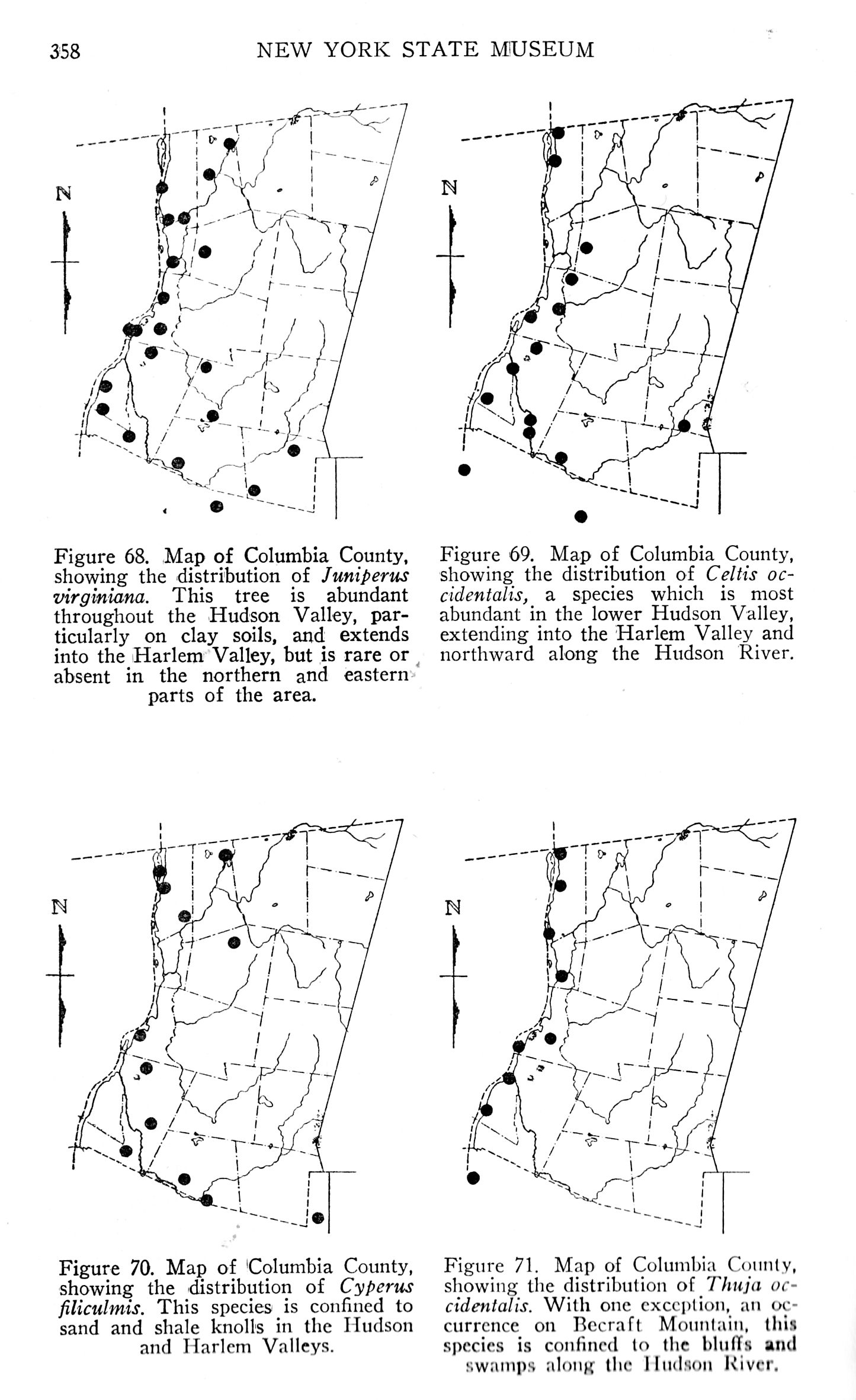
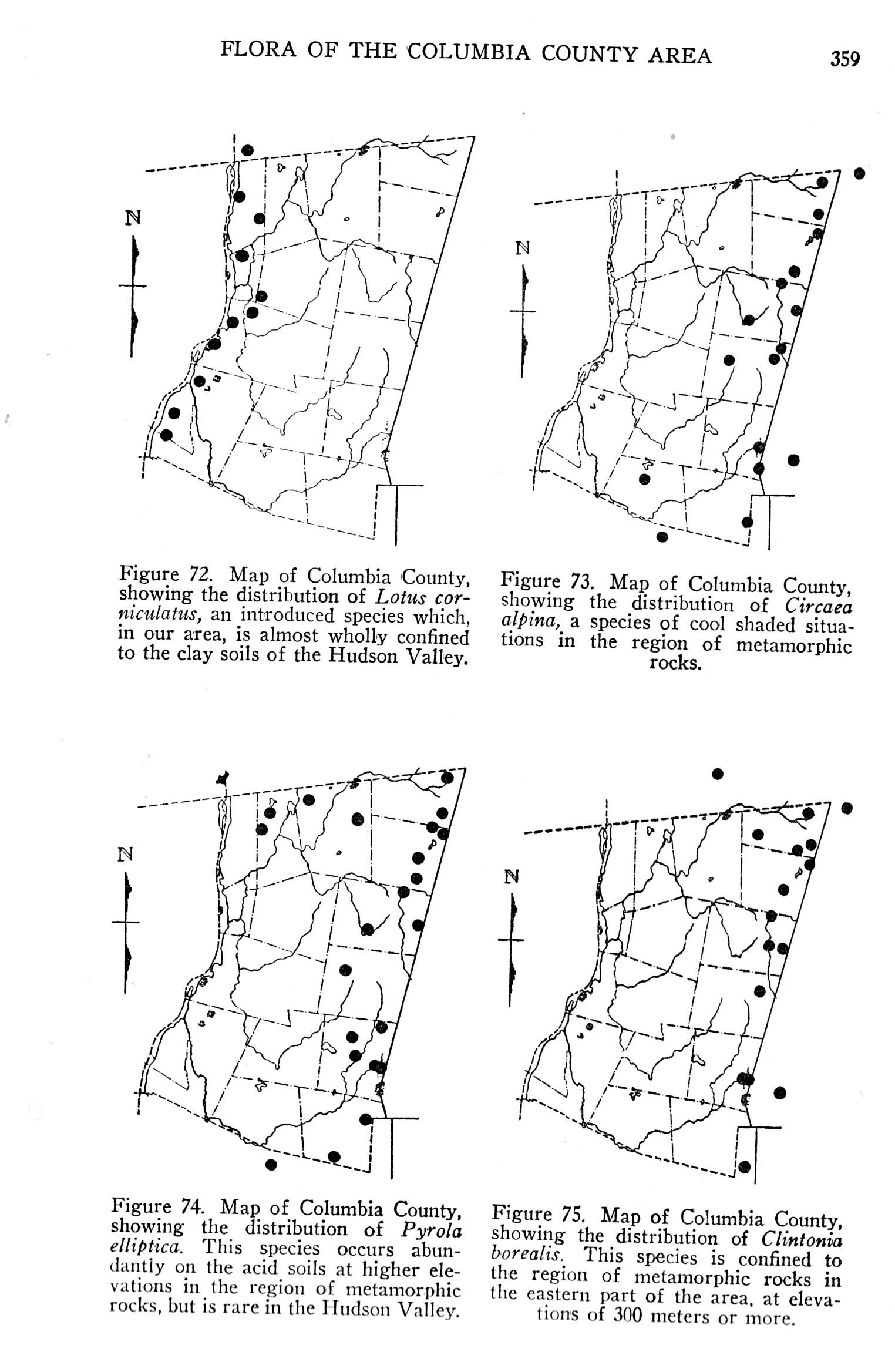
The closest we come are some of Rogers McVaugh's range maps contained
in his Flora. Those below show the east/west variation of plants, from
the warmer, sandier Hudson Valley to the colder, rockier Taconics (see
elevation map at head of this column). Our most boreal plant species
(such as Hobble Bush) tend to be found in the northeast corner of the
County; our most austral species, such Hackberry, tend to be found in
the southwest quarter.


PLANT DISTRIBUTION MAPS FROM ROGERS
MCVAUGH'S FLORA OF THE COLUMBIA
COUNTY NY AREA.
(click on image to view enlargment)
The Environmental Atlas showed the generalized distributions of a
couple of trees which illustrated that Columbia County sits on a
so-called 'ecological tension zone'. (Don't worry, there's nothing
actually tense about this tension zone, rather the term refers to a
region where distinct floras and faunas overlap, often this results in
increased biodiversity.) A more complete way of illustrating the
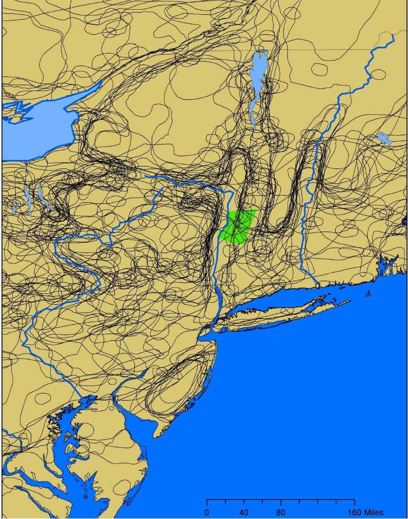
'tension zone', at least for trees is to map out various Northeastern
tree distributions and to ask whether or not there appear to be
particular regions where many species have range borders. If any such
clusters of range borders are apparent, then they could indicate
tension zones. The map below is one such graphic, it shows how Columbia
County (shown in green) and other counties along this line seem to
straddle the borders of many tree ranges. (Tree distribution data from
the US Forest Service, http://esp.cr.usgs.gov/data/atlas/little/)

THE SPAGHETTI BOWL OF TREE DISTRIBUTIONS
(click on image to view enlargment)
This same general map has also been created by Charlie Cogbill based
upon his work and that of others looking into forest types in the
Northeast. His map (slightly modified below) illustrates Columbia
County's biogeographical position again.

CHARLIE COGBILL'S SUMMARY
OF VARIOUS FOREST TYPE MAPS
(click on image to view enlargment)
What holds for plants also holds for animals. The set of maps in the
image below show how several southerly reptiles and amphibians creep
north into the County from the south, adding to our animal diversity.
At the same (but not shown here), some northerly animals reach into our
higher and cooler areas.

AMPHIBIAN & REPTILE DISTRIBUTIONS
(click on image to view enlargment)
These
patterns of north/south and east/west plant biogeography are what lay
down the ecological tapestry for the "eco" part of the eco-cultural
regions.
(Agri)Culture
The Altas also describes some of the cultural variation within the
County. It includes economic, ethnic and agricultural variation. Two of
our past reports detail aspects of this, Ecology in the Field of Time and Forest, Field and Freeway; a few examples are shown below.
Reflecting topography, as the map below shows, prime agricultural soils
are concentrated mainly in the Hudson and Harlem Valleys. This
underlying variation

(click on image to view enlargment)
then helped determine
the distribution of past agriculture, and continues to be evident the
current distribution of farming. For examples (as illustrated in the
maps below), 19th century haying was largely concentrated in the
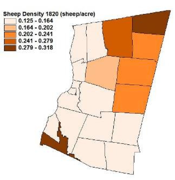
southwest corner of the County, whereas sheep pastures were mostly in
the hill towns, and grain production was highest in the northwest
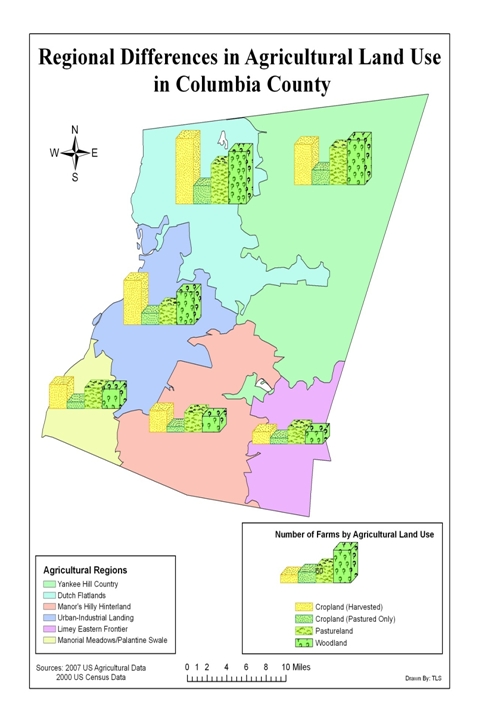
part of the County. Today, harvested cropland continues to be most
extensive in the northwest part of the County (note that the map of
modern farm types illustrates the total number
of farms in each sector in each region; the Dutch Flatlands have more
farms with harvested cropland, even though the region is distinctly
smaller than the adjacent Yankee Hill Country).

HAY PRODUCTION IN 1855
(click on image to view enlargment)

SHEEP DENSITY IN 1820
(click on image to view enlargment)

GRAIN PRODUCTION IN 1845
(click on image to view enlargment)

TYPES OF CURRENT AGRICULTURAL IN DIFFERENT
ECO-CULTURAL REGIONS
(click on image to view enlargment)
Do all these different
patterns come together and conclusively point to the seven eco-cultural
regions that we have identified? No. These patterns intertwine and
overlap in various ways, our seven regions are but one way of trying to generalize. This is a work in progress, and we'd appreciate hearing your thoughts.
|
6/17 column: "From the Ground Up"
by Conrad Vispo
From the Ground Up:
A Draft Map of Columbia County Eco-Cultural Regions
When my son and I sit down to design a model train layout we
start with a clean sheet – be that a new piece of paper, a blank computer
screen, or an empty piece of plywood. From there, we build our railroad, our
curves, our tunnels, our hills, our valleys, our villages. We create obstacles
to be overcome and shape the terrain to our wants. Luckily for all of you who
ever hope to actually get anywhere by train, my son and I were never in charge
of laying out real track in Columbia County. But even for the most expert
railroad engineer, no such ‘blank slate’ approach to laying out rail in
Columbia County was ever possible; nor, for that matter, was any human activity
ever draped uniformly over this land.
Instead, ranging hills and meandering creeks pushed up and
dug down into the land, throwing up obstructions to human movement and resulting
in water flows that powered early industry.
Likewise, the Hudson and its precursors left flatter lands and deeper
soils across the western part of the County, an invitation to early farmers.
Ridge tops beckon high-end homes; the former ports of the Hudson develop
suburban rings; the thin-soiled rocky hill farms revert to forest. Human
culture was not and is not spread evenly across the landscape.
In a simplified way, one can look at the patterning of human
culture in the same way as one looks at the formation of soil, recognizing that
what we see today has been shaped by what arrived from elsewhere, by what
spontaneously developed in situ, by the
influence of surrounding conditions on the present, and by the legacy of past
history. The shape of the land helps determine how and where people and wild
organisms live. Thus it is possible to talk about “eco-cultural regions”, that
is divisions of the County that share topographical, ecological, and cultural
features. Such reasoning also explains,
in part, the purpose of proposing these eco-cultural regions in the first place:
history and landscape have mattered, do matter, and will matter. So, as we
think about the future shape of the County, a better understanding of its
mosaic of history and terrain will help us take into account an important moulding
force.
Below, we present some of our first thoughts on Columbia
County’s eco-cultural regions. These regions are not necessarily real in the
sense that they could be identified on the basis of any strictly objective
combination of characters. Take them as crude paintings of our county -- one
way of looking at the County but certainly not the only way. Furthermore, even
if they have some rough value, they are hardly precise. Cartography asks for
boundaries, but any eco-cultural transitions are gradual, blurred and
intertwining – characteristics not easily shown on maps. Our map is an attempt
to lasso the clouds. We hope that these regions ring true to some degree, but
are also sure that they will ring false to some degree. Because so much of such
analysis depends on census data and those are often reported at the town level,
we have, with one exception, used towns as our building blocks. Please let us
know what you think; the regions described here are just first suggestions.
For each of the regions, we give a glimpse of human and
natural history, and of current conditions. Incorporating Native American history
into this picture would have been good, but so much of their land use patterns
and local legacy have been lost in time that we, at least, forgo the attempt.
Dutch
Flatlands.
The Dutch Flatlands are comprised of the towns of
Stuyvesant, Kinderhook, Claverack and Ghent. The western half of Chatham
probably also best fits here.
The Dutch first settled in the northwest portion
of the County for good reason: the land is relatively flat; the soils
relatively good; there was easy access to the main route of transportation, the
Hudson River; and the drops along the main stem of Claverack and Kinderhook
Creeks provided prime sites for mills. Much of the land remains unforested and
some of the County’s most extensive fruit and vegetable farms are in this
region. The proximity of the Capital District means that land use for farming
competes with that for commuter housing. The majority of the workforce is
employed in Albany and its environs. Salaries are relatively high and the
second-home market relatively small.
The sandy beaches of glacial Lake Albany make up
part of this region. These soils were probably covered mainly by Oak and
Hickory, although, where sandiest, White and Pitch Pine reportedly formed large
stands that extended into Rensselaer County. During the precolonial period,
fire, caused by lightening or humans, may have been most extensive on these
generally well-drained soils. Although punctuated by steep drops, the Kinderhook
and Claverack Creeks become more level as they run through this region and
extensive floodplains result.
The
Yankee Hill Country
The Yankee Hill Country includes the towns of New
Lebanon, Canaan, Austerlitz, and Hillsdale. The eastern half of Chatham lies
within this region. The Hill Country is dominated by the ridge of the Taconics,
which delineates the County’s boundary with Massachusetts.
For the most part, this region was settled by
Yankees escaping the demographic pressures of New England. The Dutch held the
flatlands, but were less interested in the steeper, thinner-soiled hill
country. The new settlers found some fertile land in the valleys of New Lebanon
and Hillsdale. In the early 1800s, Shaker settlement created a hub of
agricultural and manufacturing activity. The thin soils and hilly country were
most suited for pasture, and this area, together with Clermont, was the core of
the County’s 19th century sheep raising. The streams, though
relatively small, have good incline; small saw and grist mills were common,
together with some limited manufacturing. Farmland abandonment came early.
Between 1875 and 1930, loss of improved acreage approached 50% in some towns.
Much of that farmland has reverted to forest and, as a consequence, this
region, together with the Manor’s Hilly Hinterland (see below), are the most
forested parts of the County. At present, this region is relatively thinly
settled, although its ridges and scenic views have attracted the building of
second homes.
These lands harbor our most boreal creatures. Red
Spruce and Hobblebush creep into the more northerly portions. Breeding birds
more typical of the Adirondacks, Catskills or Appalachians, such as Canada,
Black-Throated Green, Black-throated Blue and Blackburnian Warblers, and the
Dark-Eyed Junco, occur here. Cooler mountain creeks are home to Brook Trout and
Slimy Sculpin. More northerly butterflies and dragonflies dip into this part of
the County.
The
Urban-Industrial Landing
We have included the City of Hudson itself and the
surrounding areas of Stockport and Greenport in this region. This is Hudson
River shoreline whose soils are dominated by finer deposits (clays and sands
vs. coarse glacial till) derived from Glacial Lake Albany. These clay deposits
provided resources for brick-making, and the limestone of Beecraft Mountain
provided raw materials for cement production.
Initially, this stretch of Hudson River shoreline
was settled by the Dutch, but density seemed to remain relatively low compared
to the adjoining Dutch Flatlands. However, it may have been this lack of early
settlement that allowed ‘Claverack Landing’ to develop into what is now the
County’s capital and biggest city – Hudson, when Quaker entrepreneurs chose the
site for development of a trading (and, to some extent, whaling) port around
1783. By 1820, human density was at least twice that of most other regions of
the County. Initially, the areas of Greenport and Stockport were important
agricultural lands, especially for fruit. In 1881, the largest apple orchard in
the world, comprising 300 acres and 26,000 trees, was reputedly near Hudson. Only
later did those farms become partially subsumed by the more industrial and
urban aspects of Hudson. Currently, this is one of the most ethnically diverse
parts of the County with substantial African-American, Asian and Hispanic
populations.
The freshwater but tidal shoreline of the Hudson
is a globally rare habitat, and home to certain rare plants and animals.
Enticing glimpses of inland ecology may be found near Olana and along the
Claverack Creek, where Beaver, nesting Blue Heron, and one of our few known
Leopard Frog populations occur within city limits. Box Turtles, which are a
more southerly species, occur at least as far north as Hudson. The forests were
probably Oak and Hickory dominated, but Northern White Cedar and Hackberry are
surprisingly common along the riverbanks.
Manorial
Meadows
The towns of Clermont and Livingston were the
heart of the Livingston Manor, a semi-feudal domain granted to Robert
Livingston in the late 1600s. As with other patents, farmers of this area did
not own their land, but rather worked it in return for rent provided to the
Manor lord. The Crown purchased part of the Manor in 1610 as land for the
settlement of Palatine Germans; this later became Germantown (see below).
Colonial agriculture on these mostly flat, good
soils somewhat paralleled that of the Dutch Flatlands, with the land being
opened relatively early and grain being a common crop. However, unlike on the
Flatlands, Robert H. Livingston’s fascination with sheep (he wrote a book on
them) resulted in the region’s early participation in the sheep boom and,
perhaps due to the cutting of tidal meadows and upland swales, these towns
produced substantial hay. The growing of small grains extended into corn
growing, and silage-based dairying. This was supplemented by fruit growing. By
the end of the 20th century, production agriculture seemed to have
faded in Clermont, where fruit growing and dairying were notably lower than in
Livingston; modern horse farms have, however, become more common in this town.
This is probably the warmest region of the County,
and more southerly plants such as Flowering Dogwood, Tulip Tree, and Hackberry
become particularly common. The forest is still Oak and Hickory dominated.
Certain more southerly species such as Box Turtles may also become more common
in this area. The Hudson’s tidal shoreline and waters are home to a set of
relatively rare plants and animals.
The
Palatine Swales
Germantown was originally part of the Livingston
Patent, but was settled by German Palatine emigrants in 1710 as part of an
effort to establish a production center for “naval stores” (i.e., pine pitch
used in making tar). Although this venture soon failed, settlers did receive
common ownership of their lands unlike the rest of the Livingston Patent’s
tenants who had to wait until the nineteenth century (or later, if they became
renters). This distinct cultural origin and tenure arrangement, together with its
low fertility soils, produced a distinct historical trajectory that seems to
warrant separating this town from the rest of the Manor. Although the land is
relatively flat, and the soil generally deemed poorer than that of the
surrounding Manorial Meadows. Gentle north/south ridges formed by the
underlying bedrock result in a series of wetter, richer swales.
That Germantown agriculture was somewhat distinct
is hinted at by Spafford’s 1813 comment that “By a timely economy of forest
trees, the lands in this town are remarkably well supplied with timber, and no
Town on the tide waters of the Hudson has groves of equal value.” As with the
Manorial Meadows, hay was a 19th century agricultural staple, but
sheep were rarer, and grains and dairying more common than in that region.
Dairying lost relative importance to fruit production in the 1900s. Germantown
never had much industry nor is it particularly close to the Capital District.
With the decline of orchards in the County, Germantown’s economy suffered.
About half of the workers residing in the Town are employed outside of Columbia
County, predominantly in nearby Dutchess County.
As befits our warmer grounds, the forests tend to
include some of the more southerly trees and shoreline biodiversity mentioned
in our discussion of the Manorial Meadows. Indigenous settlements may have been
relatively common, and, on drier, warmer lands may have encouraged more
frequent fires. Furthermore, a map of lightning activity indicates that it
tends to be particularly common in this region, again hinting at the
possibility of increased historical fire occurrence.
The
Manor’s Hilly Hinterland
The modern-day towns of Taghkanic and Gallatin
composed the center portion of the Livingston Manor. Located on hills that
stretch southwest from the Taconics and having neither the good limey soils of
the Harlem Valley (see below) to the east nor the flatter, lake-derived soils
of the Manorial Meadows to the west, these towns experienced relatively poor
agricultural conditions in terms of both tenure and land quality.
Although home to one of the earliest iron forges
in the County, little additional industry developed in this region. Perhaps
stimulated by the poor soils, three of the County’s five plaster mills were
found in this region; ‘plaster mills’ ground gypsum (a sulfurous lime) into a
powder that was used as a fertilizer. As with the Limey Eastern Frontier,
agriculture was initially slow to develop. Unlike in the Eastern Frontier,
subsequent development was also not particularly strong and the maximum extent
of improved acreage was the lowest of any region (although it still did exceed
70% of the surface area). There was no obvious early agricultural specialization,
although early statistics suggest relatively high pig production. Human
population density has remained fairly low, although the hills and easy access
from the Taconic State Parkway have now encouraged the spread of second homes.
Ecologically, this hill country presents something
of a mix between the more boreal elements of the higher and more northerly
portions of the Taconics and the more southern elements that creep in from
Dutchess County. This is, for example, the only region in the County where we
know that Marbled Salamanders, a southerly species, occur. Likewise, the
Worm-Eating Warbler, generally a more southerly bird, occurs in this area. Neither
the shoreline nor limestone-loving organisms of the Manor’s other sections are
common here.
The
Limey Eastern Frontier
The towns of Ancram and Copake in the southeast
portion of the County are located on relatively good agricultural soils because
of the flattish lands of the Harlem Valley and the underlying calcareous
bedrock. Their early colonial settlement and development may have been hampered
somewhat by the tenure system of the Livingston Manor and by the long uncertainty
over the location of the boundary with Massachusetts. Hills to both the east
and west somewhat isolated these lands. In 1820, this was the most
sparsely-settled portion of the County.
Although agriculture was slow to develop, the good
soils and a rail connection to NYC (established in 1852) helped this region
become one of the core dairy lands of the County by the late 19th
century. This role has continued until the present, although dairying has
declined overall in the County. As with the Hill Country to the north, these
lands did participate in the sheep boom of the first half of the 19th
century, and beef cattle and pigs were also relatively common in the early
agricultural economy. Iron and lead mines helped spur initial industry, but
there was relatively little additional development. The only currently
functioning paper mill in the County does, however, occur here. Most recently,
the hills, scenic rural vistas, and relative proximity to NYC have encouraged
second home development, and horse farms have become particularly common in
Copake.
This is one of the most biodiverse areas of the
County (outside of the Hudson River shoreline) because of both the high hills
of the Taconics and the limestone valleys, the latter favoring a distinct set
of rare plants and animals. Certain calcareous wet meadows (called ‘fens’ by
ecologists) are home to several rare plants and even the nationally-endangered
Bog Turtle.
Maps are a reflection of the land, but the land
can also become a reflection of the maps. Those who laid out the real railroads
in this country invested much time and resources in surveying routes. Their
maps took into account the grades, the distances, the canyons, and the
mountains. The route they chose thus reflected the land it travelled through.
At the same time, the fortunes of towns were made and broken by the course the
track drew across the continent. In the same way, mapping out our communities
and looking for patterns in the land’s culture and ecology help us navigate our
surroundings. Such maps are also precursors of what is to come: if we can map
what has been and is important to us, then we can begin to see the topography
of the future. And with that topography, we have one of the tools for building
our visions.
There are many sources of information on the
County’s human and natural history and its geology. Prime among them are
Stott’s Looking for Work, Fisher’s The Rise and Fall of the Taconic Mountains,
and McVaugh’s A Flora of the Columbia
County Area, New York. Much of the work summarized here was done by my
colleagues Claudia Knab-Vispo and Anna Duhon, much of the credit goes to them,
but I’ll accept the blame.
-
Conrad Vispo.
|